This Monday, Tuesday and Wednesday are expected rains in some provinces of the Dominican territory due to the incidence of a troughwhile Oscar, who no longer represents danger for the country, it was downgraded from a hurricane to tropical storm in Cuba.
According to the Dominican Institute of Meteorology (Indomet), due to the humidity transported by the southeast wind and a trough southwest of the country in the waters of the Caribbean Sea, this Monday there were rains which in the afternoon could occur towards the northeast, northwest and the border area, especially in Hato Mayor, Samaná, Puerto Plata, Santiago, Valverde, Dajabón, Santiago Rodríguez and Montecristi.
In the case of the Great Saint Dominic are expected downpours premises in the course of the afternoon, according to the Indomet.
For tomorrow, Tuesday, an increase in the humidity for one trough and the approach of a tropical wavewhich will favor more downpours to occur from early morning towards provinces of the Caribbean coastal plain, northeast, northwest and the border area and in the morning hours, but with greater intensity and frequency in the afternoon until the early hours of the night.
While on Wednesday the country will continue under the effects of the troughin addition to the humidity left by the tropical waveboth phenomena will contribute to cloudy weather continuing to occur with downpoursthunderstorms and isolated gusts of wind, especially in the afternoon towards the southeast, northeast, Central mountain range and the border area.
Oscar
Oscar was demoted to tropical stormis located 25 kilometers west/northwest of Guantánamo, Cubaand has maximum sustained winds of 65 kilometers per hour.
This system, due to its position, movement and distance, does not represent danger direct for Dominican Republic.

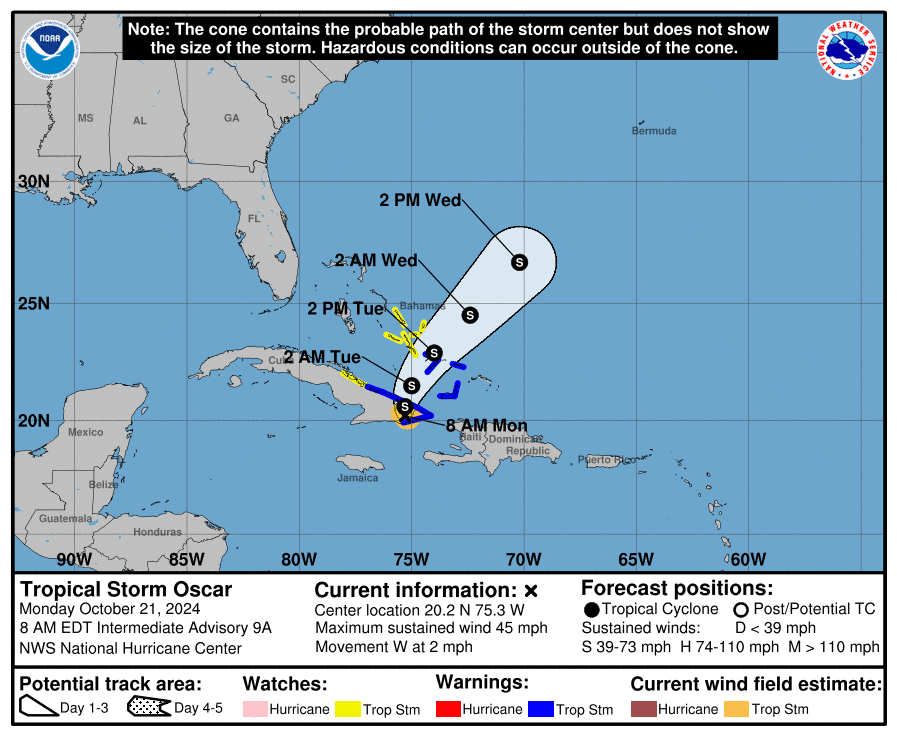
The center of the storm remains on land today Cuba.