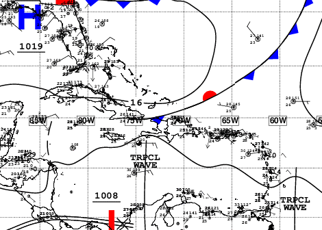
A front system (cold front) is located near the Atlantic coast of the Dominican territory and together with a prefrontal trough will continue to affect the country with rains that will last the entire weekend and with some improvement in the temperatures.
He Dominican Institute of Meteorology (Indomet) reported that the cold front It is almost stationary near the Atlantic coast in the north of the Dominican territory, while weather conditions remain favorable for them to occur. downpours local in the afternoon and early evening hours towards Greater Santo Domingo, San Pedro de Macorís, Monte Plata, Hato Mayor, Monseñor Nouel, Sánchez Ramírez, San Cristóbal, Samaná, La Vega, Santiago, Santiago Rodríguez, Duarte, Hermanas Mirabal, Espaillat , among others provinces.
As for the temperaturesin the case of National District the maximum presents a slight variation in recent days compared to the previous days of this week, according to the meteorological station of the Indomet.

The tool highlights that last Monday, October 21, the maximum temperature in the National District It was 33 °C, on Tuesday, October 22, the maximum was 32 °C, on Wednesday the 23rd, it was 32 °C, and yesterday, Thursday, the maximum was 30 °C, specifically at 4:35 in the afternoon.
Yesterday, the Indomet had reported that the approach of cold front will cause temperatures cooler while the same influence remains, because there will come a wind fresh from the north.
Rains of this Friday and weekend
In it National District this is expected Friday isolated to scattered clouds during the morning, but cloudy increases in the afternoon with downpours local thunderstorms and gusts of wind.
According to the Indometfor the rest of this night Friday and in the early morning of this Saturday the rains They will remain towards the coastal zone of provinces of the Atlantic coast as weak to moderate rain, being strong at times, a product of the cold front which is located near the Atlantic coast of the country; the prefrontal trough and the wind from the east/northeast.
Tomorrow Saturday It is predicted that the cold front is dissipating in the north of the country; At the same time, the passage of a tropical wave is expected, however, its greatest rain activity will be towards the Caribbean Sea.
“Anyway, this Saturday he wind from the east/northeast will be responsible for transporting clouds towards the Dominican territory that, together with the slight incidence of a trough, will cause rains from morning hours towards the northwest, north, northeast and southeast that will be weak to moderate with thunderstorms. In the afternoon, you are rains will extend towards the Central Mountain Range and the border area in the form of downpours moderate to strong with thunderstorms and gusts of windespecially on localities of Greater Santo Domingo, Hato Mayor, Samaná, Monte Plata, María Trinidad Sánchez, Espaillat, Duarte, Sánchez Ramírez, La Vega, Santiago, Montecristi, Dajabón, Elías Piña, Puerto Plata, San Pedro de Macorís, among others.
On Sunday, the wind The east/northeast and the trough will continue to promote a rainy environment in much of the country, especially towards the north, northeast, southeast and the Central Mountain Range.
Alerts
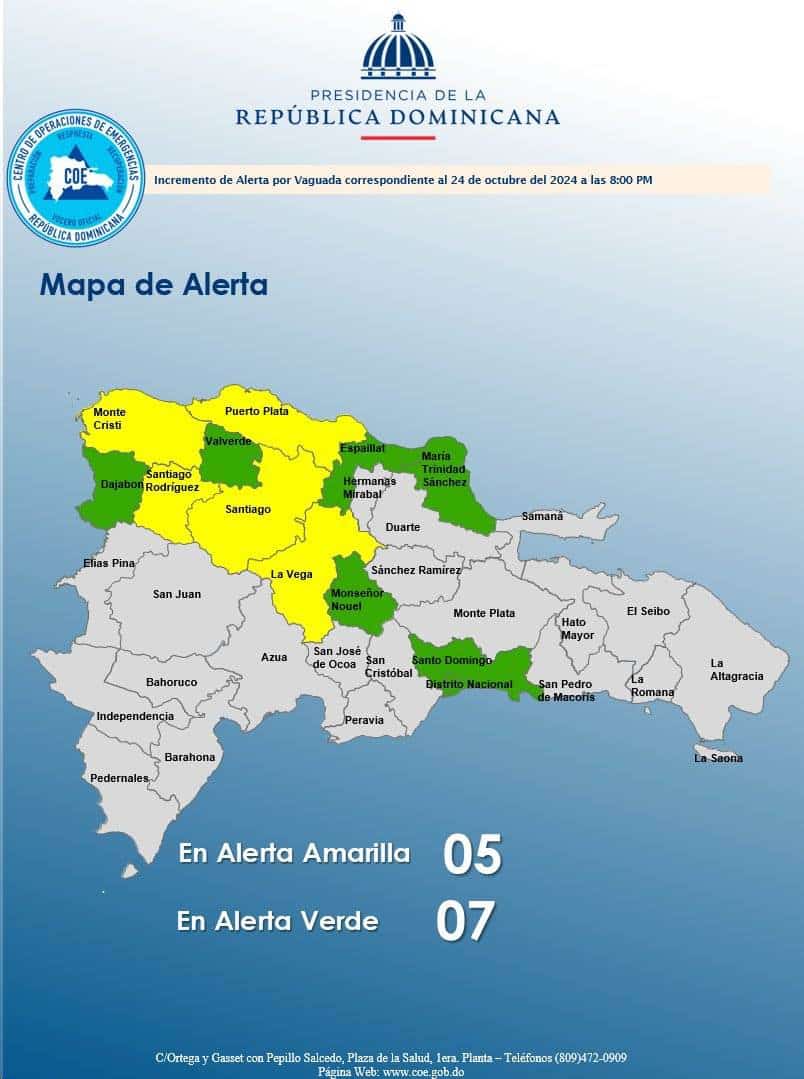
Due to the rains 12 provinces They remain on alert, of these five in yellow and seven in green.

The provinces on yellow alert are: Montecristi, La Vega, Santiago, Puerto Plata and Santiago Rodríguez.
The provinces on green alert are: María Trinidad Sánchez, Espaillat, Monseñor Nouel, Valverde, Dajabón, Santo Domingo and National District.
The Emergency Operations Center (COE) recommended that people refrain from crossing rivers, streams and ravines that have high volumes of water in the provinces under alert.


