Starting this Monday afternoon they will affect the Dominican territory particles of dust from the Sahara and an anticyclonic system, so a very humid environment will be recorded warmaccording to the report of the Dominican Institute of Meteorology (Indomet).
“It is expected that a mass of air more stable with a slight particulate of dust of the Sahara is established over our territory as a result of the incidence of high pressure; consequently the rains The rain will be limited starting with the southeast and northeast regions, however, in the afternoon there will be some clouds with showers in towns of La Vega, Azua, San Juan, Elías Piña, Dajabón, Santiago Rodríguez, Santiago, La Altagracia and Monte Plata. The rest of the provinces will have few clouds or sunny with a sunny atmosphere. warm“, the entity said.
Heat in Great Holy Sunday
In the National District, an environment of scattered clouds and a warm sensation is expected. As well as a temperature maximum between 33 °C and 35 °C and minimum between 23 °C and 25 °C.
This Sunday, for example, the temperature maximum In the National District it was 33 °C at 2:21 in the afternoon, while at 9:00 in the morning today Monday 30 °C and a thermal sensation of 41 °C were already recorded in this area, according to the meteorological station of Indomet.
Up to 39 °C in the border
However, in other areas of the country such as in places on the border line like Jimaní and the Northwest Line like Sabaneta, there have been reports temperatures up to 39°C and 38°C, respectively.
He Indomet recommended taking enough liquidspreferably waterwear light-colored, lightweight clothing, seek cool, ventilated places, avoid exposure to the sun without proper protection between 11:00 a.m. and 4:00 p.m.
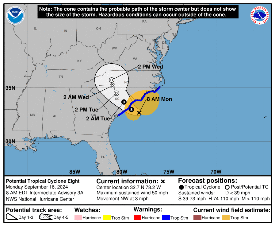
Potential is formed cyclone 8 which does not represent danger for DR
The potential was formed cyclone tropical storm #8 with maximum sustained winds of 85 kilometers per hour and located about 155 kilometers east/southeast of Charleston (South Carolina), United States.

Gordon is now a tropical depression located about 1,645 kilometers east of the Lesser Antilles with maximum sustained winds of 45 kilometers per hour, according to the United States National Hurricane Center (CNH).
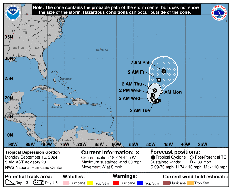
These two systems do not represent danger for the Dominican Republic.
Tuesday and Wednesday
For Tuesday, a mass of rain is expected to continue. air relatively dry and stable, with some content of particles of dust of the Sahara that will contribute to an environment of heat suffocating throughout the island, according to the Indomet.
On Wednesday during the morning and afternoon hours the rains will continue to be limited to some showers in towns in the northeast and the Central mountain range due to the effects of the anticyclonic system.