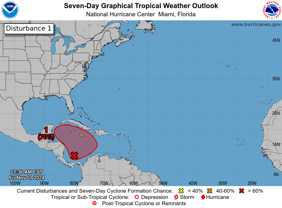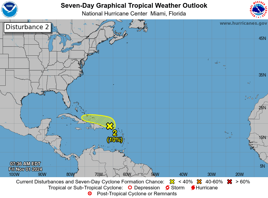
Various systems will be generating rains in it territory Dominican throughout the weekend and next week, two of these with potential for cyclonic development.
The Dominican Institute of Meteorology (Indomet) has warned about rains intense for this Friday and tomorrow Saturday mainly towards the coast north or Cibao, which from Sunday and Monday will be more intense on the Caribbean coast, in provinces such as Santo Domingo, Pedernales Barahona, Azua, San Cristóbal, Peravia, San Pedro de Macorís and La Romana.
system south of Jamaica
One of these systems is the one that has been monitored for several days and is located south of Jamaicathis has a formation probability of up to seven days high of 70% and 30% in 48 hours.
Now this system which was previously considered a possible “cyclone left-handed” is expected to move towards north or towards the northwest and not towards the northeast as previously contemplated.

“Gradual development is possible thereafter, and a tropical depression is likely to form late this weekend or early next week as the system generally moves towards north or northwestward over the central or western Caribbean Sea. Regardless of the development, they are possible rains locally strong over portions of the adjacent land areas of the western Caribbean,” indicates the United States National Hurricane Center (CNH).
Second system in Puerto Rico
The other system It is a wide trough northeast of the Greater Antilles, near Puerto Ricowhich has a 10% probability of cyclonic formation in 48 hours.
“Regardless of the development of this systemare possible rains locally strong over the next few days from the Leeward Islands of the north westwards through Puerto Rico and Hispaniola (Dominican Republic and Haiti) to the east of Cuba and the southeast of the Bahamas,” says the CNH.

Friday and rainy weekend
This Friday the territory Dominican will remain under an environment wet and unstable, since the wind will remain moderate from the northeast and the trough will continue to have an impact, so it is expected rains weak to moderate, being occasionally strong from the morning, especially towards La Altagracia, El Seibo, Hato Mayor, Samaná, María Trinidad Sánchez, Duarte, Hermanas Mirabal, Espaillat, Puerto Plata, Santiago and La Vega. All these are provinces eastern and coastal north.
“On this Friday afternoon, the rains will continue more frequently and intensity in the provinces mentioned above and will extend towards Greater Santo Domingo, La Romana, San Pedro de Macorís, Monte Plata, Elías Piña, San Juan, Pedernales, Barahona and Montecristi, until the early hours of the night. During the night hours, the continuation of the rains toward provinces close to the Atlantic coast,” says Indomet.
Tomorrow, Saturday, trough will be moving westward with its axis to the north/northeast of the country, probably being a low pressureand will induce a wind warm and wet from the south that will begin to drag quite a bit humidity coming from the disturbance zone in the southwest of the Caribbean Sea (which is south of Jamaica and could become a tropical depression).
“In the morning hours of Saturday, the rains will continue towards the Atlantic coastal area of provinces from the southeast, northeast, north and northwest, intensity variable with thunderstorms and gusts of wind. In the afternoon, they will intensify as showers in provinces such as San Cristóbal, San José de Ocoa, Monseñor Nouel, La Vega, Santiago, Santiago Rodríguez, San Juan, Elías Piña, Gran Santo Domingo, among others nearby, until the early hours of the night,” highlighted the Indomet report.
Sunday
For Sunday, the probable low pressure will continue to move westward with its axis northwest of the territory Dominican and wind of the south will continue to drag humidity coming from the possible tropical depression in the southwest of the country.
“This will cause some episodes of rain toward provinces of the Caribbean coast that, in the afternoon, will intensify as moderate to strong downpours with thunderstorms and gusts of wind. wind that will extend to the rest of the country, especially to the southwest, southeast and northwest,” he points out.
A lot humidity in atmospherewhether or not the cyclone
The director of the Dominican Institute of Meteorology (Indomet), Gloria Ceballos, stated that regardless of whether the system located south of Jamaica may or may not become a cyclone tropical, the most important thing is the content of humidity what’s in the atmosphere of the territory Dominican.
“In the images you can practically see a river of humidity in the atmosphere ours, which is the one that is generating those rainswhich since the beginning of the week have been happening along the entire coast north and northeast of the country,” he said.
Call to the population
The Operations Center Emergencies (COE) called on the Dominican population not to be careless due to the significant accumulated rain that are expected this Thursday, the weekend and early next week.
In a press conference in conjunction with the prevention and relief institutions, Juan Manuel Méndez, director of the COE, called the people’s attention also because it is a long weekend (Monday is a holiday) and already over the country they have been registering rains During the last week, the soils have been saturated.
“Let the population not be careless, we have several days of rains and alerts, all rains that may fall from this moment become surface runoff and cause floods whether urban or rural,” said Méndez, highlighting in the case of the National District only 50 millimeters of rains can cause floods.
He remembered that with nature there is no control, and that by virtue of the rains that are expected there cannot be carelessness”.
“With nature there is no control, there is no November, there is no May, there is no June, when an event occurs the response to what happened is organized, we cannot act before it happens, we only have to prepare… but “Only God knows what is going to happen, gentlemen,” said the official.
Méndez recommended that the population strictly monitor the information meteorological and be careful on the roads when traveling. It also recommends that citizens avoid throwing garbage into the streets and avoid taking garbage out to the streets on those days, because this clogs the scuppers, making it easier. floods urban.
Alerts
THE COE placed 13 provinces on alertsix of these in yellow and seven in green.
In yellow alert are: Puerto Plata, María Trinidad Sánchez, Espaillat, Hato Mayor, El Seibo and Samaná.
The provinces in green alert They are: Santo Domingo, National District, La Vega, Montecristi, Duarte, Hermanas Mirabal and La Altagracia.


