He Institute Dominican of Meteorology (Indomet) reported that the rains will continue this Sunday due to an area of instability located in the north of the country.
Indomet explained that two meteorological phenomena are generating conditions of humidity and instability in the Dominican territory. This is a trough located to the north, with low potential for cyclonic development and another extensive area of low pressure in the southwest of the Caribbean Sea, which has a high potential to evolve into depression tropical.
According to the forecaster Julio Ordoñez, currently the low pressure will continue to cause weak to moderate rains, with storms Isolated electric shocks and gusts of wind in various areas of the country.
The rain is expected to intensify in the afternoon, with downpours moderate to strong that could last until the early hours of the night.
“While in the southwestern Caribbean Sea, specifically between Panama and Colombiathere is a 90% chance that this system will become depression tropical in the next 24 to 48 hours. However, so far it does not represent a direct threat to the Dominican Republic, since it is expected, according to its trajectory, to move away from the island,” he pointed out. Ordoñez.
Ordoñez He also indicated that, if he reaches the category of cyclone tropicalthis phenomenon would be named “Raphael“. The provinces with the highest incidence of rain would be Greater Santo Domingo, Pedernales and Barahona.

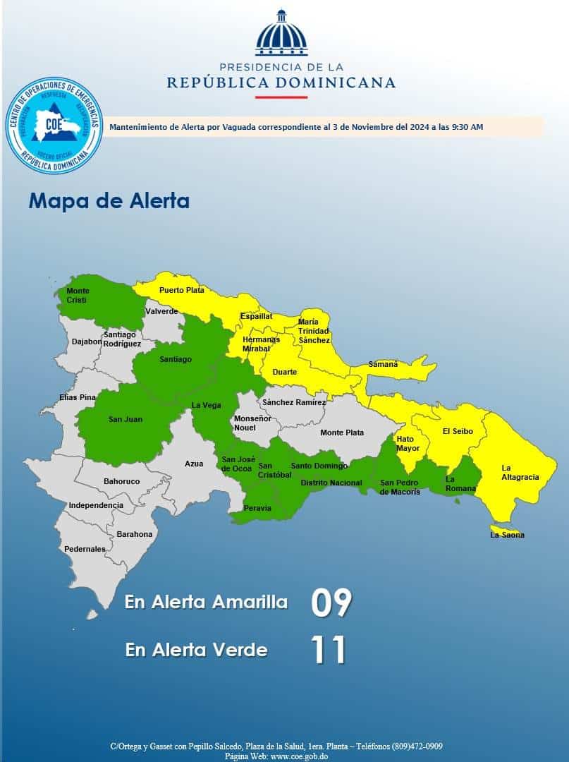
Coe keeps 20 provinces on alert
The Center of Operations of Emergencies (COE) maintains the number of demarcations under 20 alert due to the incidence of a disturbance tropical with potential to become cyclone tropical in the next 48 hours.
Currently, the provinces in alert yellow are: Puerto Plata, Duarte, María Trinidad Sánchez, Espaillat, Hermanas Mirabal, Samaná, El Seibo, Hato Mayor and La Altagracia.
The demarcations in alert green include the National District, Santo Domingo, Santiago, La Vega, Montecristi, San Cristóbal, San Pedro de Macorís, La Romana, San José de Ocoa, Peravia and San Juan.
He Institute Dominican of Meteorology reported that the phenomenon will continue to produce cloudy weather with downpours of moderate to strong intensity, accompanied by storms electric and wind gusts in the north, northeast, southeast, southwest and the Central Mountain Range.


